Cranfield University, Bedfordshire, and run on behalf of Network Rail, has investigated novel methodologies for integrated flood risk modelling of rail infrastructure.
Delays are costly for Network Rail. 2012/13 was the second wettest year in the UK national record and resulted in significant disruption to rail services and infrastructure. Some £136 million in compensation was paid to train operators in consideration of unplanned delays and cancellations in that year. Winter 2013/14 saw more challenging weather conditions and impacts on delays. In February 2014 the Department of Transport announced it would provide £31 million to fund rail resilience projects in the South West including the installation of rainfall, river flow and groundwater monitoring at key risk locations.
 Flooding is a major contributor to rail delays. To help develop a proactive approach to flood risk assessment, a project was commissioned at Cranfield University to develop methods and tools to help Network Rail. The project was conducted by students from the Masters courses in both Environmental Informatics and Geographical Information Management. The project set out to address a number of key objectives. First, to evaluate existing flood risk assessment methods and flood models to identify techniques applicable to Network Rail’s infrastructure; second to develop approaches for flood risk modelling utilising datasets provided by Network Rail, as well as other available data within 3 selected study areas (fluvial, coastal and surface run-off); thirdly to implement the approach within a GIS framework; and fourthly to develop a web tool to enable visualisation of risk assessments by non-GIS experts.
Given the size and scale of Network Rail’s operations, it is unlikely that there is a single solution to predicting flood risk to Network Rail’s assets. However, this project saw the development and use of a data analytical technique from the world of ‘Big Data’, called CART, or ‘Classification and Regression Tree’. Use of CART ‘inference algorithms’ has helped ascertain the key contributory factors for helping explain the flooding events in the case study areas selected. CART profiles were used both to examine static ‘legacy’ data, as well as more dynamic time-series data. The use of these techniques has helped identify a customised data-oriented approach to flood risk modelling that shows considerable promise, and which could now potentially be extended to other parts of the network beyond the case study areas, as well as to other types of incident (for example, landslips or embankment failures). The approach adopted should be seen as complementary with traditional hydrological modelling approaches that would need to be undertaken for specific site requirements. However, further development of the data driven method, and a systematic approach to reviewing incidents and communicating flood risk to stakeholders, may provide further opportunities to reduce the costs of delays.
Flooding is a major contributor to rail delays. To help develop a proactive approach to flood risk assessment, a project was commissioned at Cranfield University to develop methods and tools to help Network Rail. The project was conducted by students from the Masters courses in both Environmental Informatics and Geographical Information Management. The project set out to address a number of key objectives. First, to evaluate existing flood risk assessment methods and flood models to identify techniques applicable to Network Rail’s infrastructure; second to develop approaches for flood risk modelling utilising datasets provided by Network Rail, as well as other available data within 3 selected study areas (fluvial, coastal and surface run-off); thirdly to implement the approach within a GIS framework; and fourthly to develop a web tool to enable visualisation of risk assessments by non-GIS experts.
Given the size and scale of Network Rail’s operations, it is unlikely that there is a single solution to predicting flood risk to Network Rail’s assets. However, this project saw the development and use of a data analytical technique from the world of ‘Big Data’, called CART, or ‘Classification and Regression Tree’. Use of CART ‘inference algorithms’ has helped ascertain the key contributory factors for helping explain the flooding events in the case study areas selected. CART profiles were used both to examine static ‘legacy’ data, as well as more dynamic time-series data. The use of these techniques has helped identify a customised data-oriented approach to flood risk modelling that shows considerable promise, and which could now potentially be extended to other parts of the network beyond the case study areas, as well as to other types of incident (for example, landslips or embankment failures). The approach adopted should be seen as complementary with traditional hydrological modelling approaches that would need to be undertaken for specific site requirements. However, further development of the data driven method, and a systematic approach to reviewing incidents and communicating flood risk to stakeholders, may provide further opportunities to reduce the costs of delays.
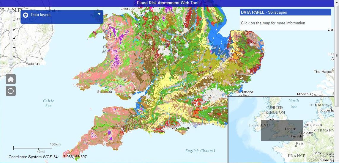 As the project concluded, a number of key recommendations emerged that would improve information used for strategic decision-making, as well as providing a platform for cost effective data driven flood risk mitigation. Firstly, the importance of clean and categorised incident data has become evident. Appropriate future mechanisms are therefore required to develop operational processes to ensure recording of new incidents capture and codify locations and, where known, the root causes of flooding. The data driven approach adopted in this study has delivered impressive and promising results, but further studies should now be undertaken to develop data driven prediction of asset flood risk further. Such work could commence, for example, with a target route network and use an iterative approach. Another outcome of the work has been in identifying the importance of adopting the means to visualise and communicate visually the modelling results. The web-based portal developed for dissemination of the flood risk profiles, flooding alerts and other data sources, direct from GIS, has proved a powerful means to communicate risk. Further to this, the project has also usefully trialled the use of 3D ‘virtual reality’ visualisation and projection techniques for analysing flood incidents, and educating stakeholders in improved flood risk management. The benefits of a range of software tools were evaluated. Overall, it is seen that the techniques and tools developed during this project can contribute usefully to managing the rail network and related national critical infrastructure.
Dr Stephen Hallett, whose students undertook the project, said: “This project has provided Network Rail with a powerful methodology for undertaking integrated flood risk assessment, made all the more timely after the recent extreme flooding events. The approach adopted highlights how a data-driven approach can help account for contributory factors to flooding, both proximal to the track, but also in the surrounding catchment areas, such as soil type, landuse, land cover and meteorological conditions.”
Student Project Leader: David Medcalf
Student Team Members: Usman Muhammad Buhari, David Cavero Montaner, Jose J. Cavero Montaner, Santiago Gamiz Tormo, Life Magobeya, Kerry Mazhindu-Page, Alan Yates.
Academic Supervisors: Dr Stephen Hallett (s.hallett@:cranfield.ac.uk), Tim Brewer (t.brewer@cranfield.ac.uk)
About Cranfield University
Cranfield University is a globally significant centre of expertise and enterprise in science, technology, engineering and management. The University is an exceptional environment for strongly business-engaged research and innovation and for postgraduate and post-experience education and training.
‘Environment’ is a key strategic theme at Cranfield. We have been contributing to the ‘green economy’ for over 40 years with deep expertise in environmental governance and sustainability, natural resource management, agriculture and land management, energy and the environment, environmental engineering for the treatment of water, wastes and contaminated soils and environmental health and food.
http://www.cranfield.ac.uk/environment]]>
As the project concluded, a number of key recommendations emerged that would improve information used for strategic decision-making, as well as providing a platform for cost effective data driven flood risk mitigation. Firstly, the importance of clean and categorised incident data has become evident. Appropriate future mechanisms are therefore required to develop operational processes to ensure recording of new incidents capture and codify locations and, where known, the root causes of flooding. The data driven approach adopted in this study has delivered impressive and promising results, but further studies should now be undertaken to develop data driven prediction of asset flood risk further. Such work could commence, for example, with a target route network and use an iterative approach. Another outcome of the work has been in identifying the importance of adopting the means to visualise and communicate visually the modelling results. The web-based portal developed for dissemination of the flood risk profiles, flooding alerts and other data sources, direct from GIS, has proved a powerful means to communicate risk. Further to this, the project has also usefully trialled the use of 3D ‘virtual reality’ visualisation and projection techniques for analysing flood incidents, and educating stakeholders in improved flood risk management. The benefits of a range of software tools were evaluated. Overall, it is seen that the techniques and tools developed during this project can contribute usefully to managing the rail network and related national critical infrastructure.
Dr Stephen Hallett, whose students undertook the project, said: “This project has provided Network Rail with a powerful methodology for undertaking integrated flood risk assessment, made all the more timely after the recent extreme flooding events. The approach adopted highlights how a data-driven approach can help account for contributory factors to flooding, both proximal to the track, but also in the surrounding catchment areas, such as soil type, landuse, land cover and meteorological conditions.”
Student Project Leader: David Medcalf
Student Team Members: Usman Muhammad Buhari, David Cavero Montaner, Jose J. Cavero Montaner, Santiago Gamiz Tormo, Life Magobeya, Kerry Mazhindu-Page, Alan Yates.
Academic Supervisors: Dr Stephen Hallett (s.hallett@:cranfield.ac.uk), Tim Brewer (t.brewer@cranfield.ac.uk)
About Cranfield University
Cranfield University is a globally significant centre of expertise and enterprise in science, technology, engineering and management. The University is an exceptional environment for strongly business-engaged research and innovation and for postgraduate and post-experience education and training.
‘Environment’ is a key strategic theme at Cranfield. We have been contributing to the ‘green economy’ for over 40 years with deep expertise in environmental governance and sustainability, natural resource management, agriculture and land management, energy and the environment, environmental engineering for the treatment of water, wastes and contaminated soils and environmental health and food.
http://www.cranfield.ac.uk/environment]]>
Cranfield University GeoThread Blog